Estimating the Population Density and Trend of Soemmerring gazelle in Hrey Gereb (Buri Peninsula), Northern Red Sea Zone, Eritrea, North East Africa
Soemmerring gazelle, scientifically named as Nanger soemmerring and a local name is Bus’adu (Afar, one of region of the state), smooth pelage, their shoulder height ranges between 81- 91 cm. and weight between 35 – 45 kg. Body coloration consists of a light tawny-brown or fawn color. Their head and neck are gradually lighter. A seasonal migrant with a herds composed of more than 15 individuals are identifiable features. These are often herds of females and their young, accompanied by a single adult male on his territory. Widely distributed throughout most of Djibouti, northern Somalia and the central coastal plain; north-east and central Sudan; lowland areas of Eritrea, the Ogden and other lowland areas of eastern Ethiopia [1]. Uncontrolled hunting and habitat destruction have most probably eliminated this species from its historic range in Sudan [2]. It still occupies substantial parts of its historical range in Djibouti, Somalia, Eritrea, and Ethiopia, but at lower densities and as isolated populations. Soemmering gazelle is endemic to the Horn of Africa. Data were collected in Hrey Gereb, Buri Peninsula, Eritrea, from two different seasons to get accuracy of this species of this area. The authors used line transacts methods to know the presence and density of the species. For this entire study the authors found 272 species throughout the period of study and the population density is 0.9921 per sq. km. was recorded. Vegetation mostly acacia, zizipus, calotropis and mangrove are available for feeding. Its population is gradually decreasing due to poaching, migration, draught and protracted wars with the neighboring states, as stated by the local population of the research area. Since, this species is vulnerable, it should be protected and though the Government of Eritrea has given a proclamation rules no. 155/2006 to conserve and protect and yet little poaching practices is going on, and still is required to save and preserve its species, as the data indicates their abundance is decreasing.
Introduction
Buri peninsula, located in this range 15000’ to 15030 N and 39048 to 40006’ E, is situated in Northern Red Sea zone under the administration of Gelae’lo sub zone in Eritrea. Most of the inhabitants are a far ethnic group, with few Saho and Tigrigna. They depend on fishing activities; some of them also raise domestic animals: camels, sheep, and goats. Buri peninsula lies in few meters above sea level, as a result it experiences high temperature during the summer from May to August and rainy season from December to February and some places may go dry for several years without rain. Rain is variable along the peninsula. The western part of the reserve is dominated by mountains and outcroppings bisected by wadi (temporary watercourses). The eastern portion is a mixture of red soil and reg (gravel plains) [1]. The climate is hot and arid. Rainfall is localized and variable and falls from late December to early March. Temperature is variable, ranging between 24-41oC during the hot season in May and June and dropping in December and January.
Buri peninsula includes different villages and is known for its rich wild life diversity like Soemmering’s gazelle, are and other species, as the researchers are concerned. Its topography and vegetation is variable and accordingly the distribution of the wild life also influenced. Likewise, it can be seen and studied under different sub divisions of this area.
The Research site: The author took different study sites and stated as follows
Plains of Gelae’lo and Bardole- Dohel plains (South part) It is characterized by high temperature, sandy soil, scattered vegetation, devoid of grasses (only along water courses), acacia species, seasonal shrubs and herbs. Hrey Gereb area (Eastern part) Hrey Gereb is a place under the administration of Duluh which is around 28 km north from Gelae’lo, Buri peninsula, in Zoba Northern Red Sea. The fauna in this area include: Soemmering gazelle, and other species. These species are listed as vulnerable in the IUCN red list. Hrey Gereb is characterized by variable topography: plains, hills, water-courses; moderate temperature, rich in vegetation: trees, herbs, shrubs; relatively available seasonal water, natural reservoir, drainage system (watershed), and rain begins earlier.
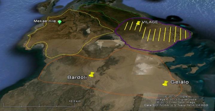
Figure 1: Sub classification of Buri peninsula - Hrey Gereb with transect lines (Image from Google Earth). Mekae’nile area (Western part) Desert with scattered vegetation, sandy soil, most rivers drain to red sea and acacia are dominant species. Duluh and Ingel area (Northern part) Desert with scattered vegetation, low seasonal water, rain is variable. Therefore, this sub classification (Figure 1) helps us to begin our protected areas according their available resources and wild life species phase by phase. Out of these places which the authors can suggest is Hrey Gereb area which is favorable place to be first and exemplary reserve area because of its advantages over the other areas.
Significance and Limitation of the Study
Since there were little data from previous studies about Soemmering gazelle population, therefore, this research paper may contribute information for those who are interested to study on the conservation of this species.
The paper has faced certain limitations in its undertaking. First, obstacle to get free and independent access to information i.e. lack of proper documentation and easy access to documents. Second, the correspondent informants and cooperators too were less interested to provide information the environmental status of the study area. The third constraint was financial limitation.
Objectives of the Study
The general objective of the present thesis is study the population density, abundance and trend of Soemmering gazelle in Hrey Gereb, Buri peninsula. The specific objectives of the study are:
- To estimate the population density of Soemmering gazelle in Hrey Gereb, Buri peninsula,
- To investigate current trend of these Gazelle species in the study site
- Recommend conservation measures that can be applied to the Soemmering gazelle and other species.
Materials and Methods
Field Materials: GPS, range finder camera, rope of 100 m length, compass, map of the area, different forms for the data record are some of the most utilized materials.
Field Methods
A preliminary survey of the study area was carried out before actual field survey and general information were collected. Based on this information, sampling techniques and questionnaire were developed. The actual field survey was conducted on seasonal basis of the year 2012- 2013.
Faunal survey was conducted by walking along the transect lines. For this, map of the study area was taken and 13 transect lines from south to north were drawn having 0.54 km distance between each transect. At first, geographical position of the start and end points of the transects were identified from the map, and by using GPS the start point was identified in the field and then started to walk in straight lines following constant easting as much as possible according to the feasibility of the topography. Perpendicular distances were directly measured using the range finder camera and the cluster size was recorded through direct count, and at some time photographs were used to avoid disturbances. In addition to this, their foot prints, scats and other indirect signs were recorded. In addition, all wildlife signs were observed in both side (up to 5m distance) of the transect lines and recorded in the data sheet. The results were computed by software “PROGRAM DISTANCE 6.0 Release 2” [3].
Faunal survey was conducted by walking along the transect lines. For this, map of the study area was taken and 13 transect lines from south to north were drawn having, 0.54 km distance between each transect. At first, geographical position of the start and end points of the transects were identified from the map, and by using GPS the start point was identified in the field and then started to walk in straight lines following constant easting as much as possible according to the feasibility of the topography. Perpendicular to this course, direct observation of the species, their foot prints, scats, or by pellets and other indirect signs were observed for absolute density. In addition, all wildlife signs were observed in both side (up to 5m distance) of the transect lines and recorded in the data sheet.
Results
Survey Results
Survey conducted for a one year 2012-2013, in different places of gelae’lo sub zone. Here the researchers visited the villages of Bardole, Gelae’lo, Duluh, Ingel, Mekae’nile, smote, Bada, Assae’lla and Hrey Gereb. These villages lie within and outside of the Buri peninsula. The survey was intended to collect information on Soemmering gazelle distribution.
Contents of Observation layer 'Observation' and all fields from higher layers Study area Region Line transect Observation ID label ID Label Area ID Label Line length ID Perp distance cluster size
3 L3 4.93
1 Herey Gereb 1 Herey Gereb 275
4 L4 5.23
1 L1 4.23 1 0 0 2 L2 4.63 2 135.9 2
3 103.5 2 4 178.2 3 5 350.8 3 6 312.2 6
7 124.6 4 8 369.6 6 9 32.5 4 10 70.5 3
5 L5 5.63 11 385.8 4 12 125.4 2
| 6 | L6 | 5.74 | 13 | 324.9 | 7 | |||||
|---|---|---|---|---|---|---|---|---|---|---|
| 14 | 268.54 | 5 | ||||||||
| 15 | 26.03 | 1 | ||||||||
| 7 | L7 | 5.93 | 16 | 102.69 | 3 | |||||
| 17 | 45.9 | 2 | ||||||||
| 18 | 209.7 | 4 | ||||||||
| 8 | L8 | 6.34 | 19 | 179.5 | 5 | |||||
| 20 | 227.95 | 4 | ||||||||
| 21 | 361.5 | 12 | ||||||||
| 9 | L9 | 6.75 | 22 | 56.2 | 2 | |||||
| 23 | 49.5 | 1 | ||||||||
| 24 | 257.9 | 4 | ||||||||
| 25 | 191.11 | 10 | ||||||||
| 26 | 316.62 | 12 | ||||||||
| 10 | L10 | 7.6 | 27 | 154.82 | 8 | |||||
| 28 | 78.9 | 7 | ||||||||
| 29 | 87.7 | 6 | ||||||||
| 30 | 237.61 | 8 | ||||||||
| 31 | 196.8 | 9 | ||||||||
| 32 | 273.83 | 10 | ||||||||
| 1 | Herey Gereb | 1 | 275 | 11 | L11 | 7.85 | 33 | 74.68 | 8 | |
| 34 | 159.19 | 6 | ||||||||
| 35 | 302.08 | 5 | ||||||||
| 36 | 304.7 | 4 | ||||||||
| 37 | 212.39 | 7 | ||||||||
| 38 | 235.58 | 6 | ||||||||
| 12 | L12 | 6.12 | 39 | 248.6 | 3 | |||||
| 40 | 122.5 | 8 | ||||||||
| 41 | 98.4 | 9 | ||||||||
| 42 | 258.78 | 4 | ||||||||
| 43 | 134.7 | 2 | ||||||||
| 44 | 28.51 | 6 | ||||||||
| 45 | 68.7 | 2 | ||||||||
| 46 | 50.42 | 8 | ||||||||
| 47 | 35.65 | 5 | ||||||||
| 48 | 340.7 | 11 | ||||||||
| 13 | L13 | 4.6 | 49 | 134.7 | 9 |
Table 1: Data sheet of Soemmering gazelle’s distribution collected from line transacts compiled through compute program.
Data Analysis
Data was analyzed exclusively using the software PROGRAM DISTANCE 6.0 Release 2” [3]. The detailed
Density Estimates
S No Parameter Point Estimate Standard Error Percent co-eff. of 95% Percent Confidence Interval 1 D 0.99211 0.21268 21.44 0.64489 1.5263 2 N 273.00 58.524 21.44 177.00 420.00 program output is too large to be presented here and for convenience the important variables selected and are listed in the tables from 1 to 5.
variation
- Effort: 75.58000, # Samples: 13, Width: 385.6000, # Observations: 49
Table 2: Model 1: Half-normal key, k(y) = Exp (-y**2/(2*A (1)**2)).
| S No | Estimate | % CV | DF | 95% Confidence Interval | |||||||||
|---|---|---|---|---|---|---|---|---|---|---|---|---|---|
| 1 | n | 49.000 | |||||||||||
| 2 | k | 13.000 | |||||||||||
| 3 | L | 75.580 | |||||||||||
| 4 | n/L :0.64832 | 15.89 | 12.00 | 0.45962 | 0.91449 |
Table 3: Estimation Summary - Encounter rates.
Density: Numbers/Sq. kilometers; ESW: meters; Component Percentages of Var. (D) Detection probability: 45.1; Encounter rate: 54.9; Left: 0.0000; Width: 385.60. Table 3: Estimation Summary - Encounter rates.
| S No | Half-normal/Cosine | Estimate | %CV | DF | 95% Confidence Interval | ||||||||||
|---|---|---|---|---|---|---|---|---|---|---|---|---|---|---|---|
| 1 | m | 1.0000 | |||||||||||||
| 2 | LnL | -291.21 | |||||||||||||
| 3 | AIC | 584.42 | |||||||||||||
| 4 | AICc | 584.51 | |||||||||||||
| 5 | BIC | 586.31 | |||||||||||||
| 6 | Chi-p | 0.99183 | |||||||||||||
| 7 | f(0) | 0.30606E-02 | 14.39 | 48.00 | 0.22949E-02 | 0.40817E-02 | |||||||||
| 8 | p | 0.84735 | 14.39 | 48.00 | 0.63536 | 1.0000 | |||||||||
| 9 | ESW | 326.74 | 14.39 | 48.00 | 244.99 | 435.75 |
Table 4: Estimation Summary - Detection probability.
| S No | Estimate | %CV | DF | 95% Confidence Interval | |||||||||||
|---|---|---|---|---|---|---|---|---|---|---|---|---|---|---|---|
| 1 | D: 0.99211 | 21.44 | 34.05 | 0.64489 | 1.5263 | ||||||||||
| 2 | N: 273.00 | 21.44 | 34.05 | 177.00 | 420.0 |
Table 5: Estimation Summary – Density & Abundance: Half-normal/Cosine.
The following acronyms are used for estimating distribution and abundance of Soemmering gazelles of different parameters: n - number of observed objects (single or clusters of animals), L - total length of transect line(s), k - number of samples, K - point transect effort, typically K=k, T - length of time searched in cue counting, detection area for line transects, h(0) - 2*PI/v, v - PI*W*W*p, is the effective detection area for point transects, p - Probability of observing an object in defined area, ESW - for line transects, effective strip width = W*p, EDR - for point transects, effective detection radius = W*sqrt (p), rho - for cue counts, the cue rat; DS - Estimate of density of clusters; E(S) - estimate of expected value of cluster size; D - Estimate of density of animals; N - estimate of number of animals in specified area.
Discussion
Population trend and abundance of Soemmering Gazelle in Hrey Gereb
The population trend survey of Soemmering gazelle has been performed based on the record of 13 line transects with fixed width of 0.54 km., using a vehicle and if necessary on foot, each transect line was traversed and recording the populations in both sides [4, 5]. As per the guidelines of line transect distance sampling, the three measurements: sighting distance, sighting angle and perpendicular distance measured. There, lack of materials makes it difficult; instead, indirect method of measuring perpendicular distance seemed applicable. After this using, the Program Distance software data was analyzed. The population estimate has been done with the assumption that the Soemmering gazelle are evenly distributed over the study area. The ground count of the study area showed a population density of 0.992per sq. km (273 individuals with 95% confidence interval 177- 420 individuals were present). When the population estimate is extrapolated from the result Soemmering’s gazelle is expected to occur in the area of approximately 1000 km2 and is believed to reach >700 Soemmering’s gazelle. The data were presented in the Tables 3 & 4.
Since no previous studies conducted in detail about their trend, based on the study conducted and the survey results on the study area, their number is slightly increasing than the previous years. Therefore, the population trend is slightly increasing. This is mainly due the public awareness made by Ministry of Agriculture (MoA) and the implementation of proclamation of the Rule No. 155/2006, which acted as a corner stone for the enrichment of wild life and the enforcement of regulation of wild life at zoba level (conference on conservation and enhancing forest and wild life). This can be justified by the results obtained from the research conducted. That is, the population density is 0.9921 per sq. km. Some of the literature available on this aspect are Convention on Biological Diversity, East R, Global Environment Facility- UNDP, Government of Eritrea, The Forestry and Wildlife Conservation and Development Proclamation No. 155/2006’, Gazette of Eritrean Laws, vol.15/2006 No.4, Asmara, 20 Sep, Google earth images, Heckel, et al., Institute of Applied Ecology (IEA), Jacksonville Zoo and Gardens, Richard Weigl, Richard, B H, Stuart C and Stuart T, Wilhelmi F, et al., Yalden DW, Dittman et al. and IUCN SSC Antelope Specialist Group [2, 6, 7, 8, 9, 10, 11, 12, 13, 14, 15, 16, 17, 18, 19].
Distribution of the Soemmering gazelles in Buri Peninsula
As per the survey result, the range of the gazelles lies within and outside the Buri peninsula. The survey was conducted in the study area. The results are good indicators of their previous distribution / range. Historically due to many reasons, like longer drought time, war, lack of food, habitat destruction, poaching and hunting that result in poor breeding capacity, as a result, these species were declining from their former ranges. Nevertheless, after the independence the government of Eritrea and the Ministry of Agriculture (MoA) devised a means to control some of the problems, by implementing and drafting legal laws and policies toward biodiversity conservation. Issuance of Proclamation No.155/2006 for development and conservation of wild life at different ecosystems of the country and particularly the Buri peninsula is a sensible effort made by the MoA. This effort results in the slight increase in the trend of these gazelles and conservation of another wild life of the area.
Conclusion
The results of the research indicate that the population of Soemmering gazelle lies in a wide range in and outside the Buri peninsula. There are 0.992 individuals per sq. km with a 95% confidence interval of 177- 420 individuals in the whole study area of about 273 km2. When this result was extrapolated Soemmering gazelles expected to occur in an approximately 1000 km2 and their number reaches >700 in the whole Buri peninsula. The research, even though it encompasses a small area out of Buri peninsula it could be a corner stone for the process of implementing reserve area to ensure wild life diversity in national and international context and thereby to enhance tourism.
Hence dividing the Buri peninsula in to different areas helps to get the maximum benefits of biodiversity as one of the potential renewable resources on earth. Their reserve area implementation can begin with Hrey Gereb area, though it harbors diverse species, like Ostriches, Soemmering and Dorcas gazelles and it has variety of vegetation species that can support for many wild animals and domesticated animals (pastoralists from Bada and southern region stay for months in this area).
Recommendations
- Protected area management should be implemented.
- Buri peninsula implementation as protected national park should be enhanced.
- Understanding the attitude of the locals towards wildlife conservation is the key factor, which is crucial to investigate their attitude, and then it will be possible to improve their indigenous knowledge to conserve the wildlife living with them.
- Keeping track of the flowing water to the sea, especially the Akarit stream by partial diverting its flow to inland area.
- Revise and investigate what factors contribute to the decline of Soemmering gazelle in their historic range so that an immediate conservation action could be developed to halt species decline.
- Provide conservation education to the locals and raise the conservation knowledge of the central and regional state authorities so that better attention would be given to the conservation of wildlife as a whole in the region.
- Conduct further research on population ecology and demography. A comprehensive study throughout the historic range is essential in order to understand the existing reality of Soemmering gazelle.
Acknowledgements
The first author express thanks to the Directorate of Research and Postgraduate Studies, Eritrea Institute of Technology, Eritrea and the Ministry of Education, Eritrea for providing the permission and financial aid for undergoing higher education and by doing research work and both the authors express thanks to Dr. Yishak Gebrekidan, Head, Department of Biology for providing laboratory facilities for doing tabulation work and also the people of Buri Peninsula for properly responding and cooperation given to us to obtain the appropriate data for conducting research on this Soemmering gazelles.
References
-
Kingdon J (1997) The Kingdon Field Guide to African Mammals. Academic Press Ltd, London.
-
East R (1998) African Antelope Database. IUCN.
-
Anderson DR, Laake JL, Crain BR, Burnham KP (1979) Guidelines for line transect sampling of biological populations. Journal of Wildlife Management 43(1): 70-78.
-
Burnham K P, Anderson DR, Laake JL (1980) Estimation of density from line transects sampling of biological populations. Wildlife Monogram 72: 3-202.
-
Convention on Biological Diversity (CBD) Enacted: 1992-06.05, enforced: 1993-12-29 {1760 UNTS 79; 31 ILM 818 (1992) = electronic information system for international laws (CBD).
-
Global Environment Facility- UNDP (2011) Integrated Semenawi and Debubawi Bahri-Buri Irrori- Hawakil Protected Area System for Conservation of Biodiversity and Mitigation of Land Degradation. Asmara, Eritrea.
-
GoE (2006) The Forestry and Wildlife Conservation and Development Proclamation No. 155/2006. Gazetee of Eritrean Laws 15(4): Asmara, 20 Sep.
-
Heckel JO, Wilhelm FI, Kaariye XY, Rayaleh HA, Amir OG et al. (2008) IUCN 2010, IUCN - Red List of Threatened Species.
-
Institute of Applied Ecology (IEA) (1998) Gazelle Soemmerringii: In African Mammals Databank - A Databank for the Conservation and Management of the African Mammals. Bruxelles: European Commission Directorate.
-
IUCN SSC Antelope Specialist Group (2016) Nanger soemmerringii. The IUCN Red List of Threatened Species 2016: eT63541A50197739.
-
Jacksonville Zoo, Gardens (2008) Nanger soemmerringii.
-
Richard Weigl (2005) Longevity of Mammals in Captivity; from the Living Collections of the World.
-
Richard BH (1996) Wild Ungulate Surveys in Grassland Habitats: Satisfying Methodological Assumptions. Chinese Journal of Zoology 31(2): 16-21.
-
Stuart C and Stuart T (1997) Field Guide to the Larger Mammals of Africa. Struik Publishers. Cape Town.
-
Wilhelmi F, Kaariye XY, Hammer S, Hammer C, Heckel JO (2006) On the status of wild ungulates in the Ogaden region of Ethiopia. Proceedings of the Sahara- Sahelo Interest Group Meeting, Douz, Tunisia, pp: 43- 62.
-
Yalden DW, Largen MJ, Kock D and Hillman JC (1996) Catalogue of the Mammals of Ethiopia and Eritrea 7. Revised Checklist, zoogeography and conservation. Tropical Zoology 9(1): 73-164.
-
Dittmann MT, Hebel C, Arif A, Kreuzer M, Clauss M (2015) Metabolic rates of three gazelle species (Nanger soemmerringii, Gazella, Gazella spekei) adapted to arid habitat. Mammalian Biology 80(5): 390-394.
-
Institute of Applied Ecology (IEA) (1998) Gazelle Soemmerringii: In African Mammals Databank - A Databank for the Conservation and Management of the African Mammals. Bruxelles: European Commission Directorate.
-
Thomas L, Buckland ST, Rexstad EA, Laake JL, Strindberg S, et al. (2010) Distance software: design and analysis of distance sampling surveys for estimating population size. Journal of Applied Ecology 47(1): 5-14.
- In Situ Evaluation of the Anthelmintic Effect of the Aqueous Extract of Syzygium aromaticum (L) Merr and Perry on Bovine Strongyles
- Successful in Vitro Embryo Production with Oocytes Aspirated from Live White-Tailed Deer (Odocoileus Virginianus Texanus) Donors under Captivity in Northeast Mexico
- Bangladeshi Finches with their Evolutionary Thoughts (Aves: Passeriformes)
- Note on the Survival Status of Przewalski’s Horse, Equus ferus przewalskii (Perissodactyla: Equidae)
- In-Situ and Ex-Situ Protection of White-Breasted Waterhen (Amaurornis Phoenicurus) (Pennant, 1769) (Aves: Rallidae)
- Meat Examination in the Laboratory, the Acceptability and the Human Health