Comparative Studies of Ekenkpon Shale Subsurface Distribution in the Calabar Flank
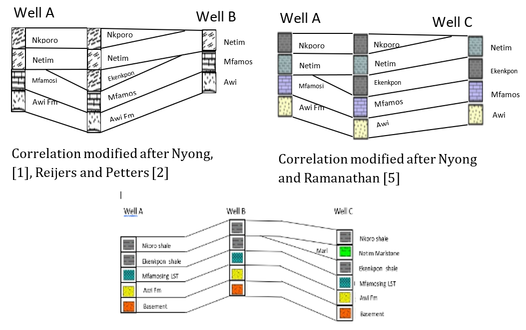
The Ekenkpon Shale is one of the Cretaceous sequences of the Calabar Flank with the structural and subsurface facies studied in terms of their distribution and lateral. Materials used in this research are processed seismic and well log data from Wells A, B and C drilled within the study area. The procedure adopted was to compare the structural and stratigraphic analysis of previous and current research carried out in the study area. Well log data were viewed matched with processed seismic data. Composite stratigraphic section generated showed correlatable the Ekenkpon Shale facies, their lateral extents and subsurface distribution. Wells A and B drilled 0.8km apart in south-central Calabar Flank and well C drilled 4.7km from well B encountered Ekenkpon Shale. Comparison of the subsurface facie distribution of Ekenkpon Shale, in Wells A, B and C showed identified facies correlated across the studied wells whereas correlations modified after Nyong, Reijers and Petters, showed that only Well B penetrated the Ekenkpon Shale which pinched out before getting to Well C NE and SW of the Calabar Flank. Analysis of works by Nyong, Reijers and Petters when compared with the current study modified the subsurface distribution of the Ekenkpon Shale. The stratigraphy established in this study showed a continuous sequence of Ekenkpon Shale from the SW to the NE of the Calabar Flank compared with the surface Ekenkpon Shale as observed at different outcrop locations by the works of Nyong, Reijers and Petters is not extensive.
Introduction
Over the years, Cretaceous subsurface sedimentary rocks of the Calabar Flank have been a conceptual illustration from surface outcrop studies. Earlier studies by Nyong [1], Reijers and Petters [2] on the structural setting and subsurface distribution of sedimentary rocks in the Calabar Flank were based on field relations, stratigraphy and sedimentological descriptions of Cretaceous sedimentary rocks exposed at different outcrop locations. The Calabar Flank was first proposed by Murat [3] that part of Southern Nigeria sedimentary basin characterized by crustal block fault tending NW-SE. The Calabar Flank is bounded by the Oban Massif to the North and the Calabar Hinge Line separating the Niger Delta Basin in the South. It is also separated from the Ikpe Platform to the west by a NE-SW trending fault has been affected by two major tectonic phases, marine transgression and regressions which played an important role in the formation of the various sedimentary sequences. The study area is characterized by metamorphic gneisses, quartzite etc. The Cretaceous sediments comprise sandstones, shales and shaly limestone as well as impure limestone. According to Adeleye and Fayose [4] the study area affected by series of orogenic processes, basin tectonism as well as global eustatic changes in sea levels. Sedimentation began with the initial deposition of fluvio-deltaic cross-bedded sands of Awi Formation in the area. The associated transgressive and regressive cycles. Calabar Flank have varying composition of deposited sedimentary rocks [5]. Sedimentary succession is predominantly Cretaceous made up of Awi Formation, Odukpani Group, Mfamosing Limestone, Ekenkpon Shale, New Netim Marlstones, Nkporo Shales and Benin Formations respectively [6]. Sedimentation in the Calabar Flank began with the deposition of the Awi Sandstones which is uncomformably overlain the Mfamosing Limestone and continued with the deposition of the Ekenkpon Shale and New Netim Marlstone. Sedimentation of the Cretaceous sedimentary rocks ended with the deposition of the Nkporo Shale Late Campano-Maastrichtian [6, 7, 8, 9, 10] (Figure 1).
![Figure 1: Stratigraphic chart of the Calabar Flank [10].](/fulltextimages/13364/fig_1.png)
Earliest studies on the geology of the Calabar Flank carried out by Reyment [7] attempted to establish the biostratigraphy of the basin, Reyment [7] however identified it as part of the Benue Trough while Murat [3] suggested that the Calabar Flank underwent phases of tectonism and stratigraphic development in comparison to the adjacent Anambra Basin and lower Benue Trough hence classified it as a distinct basin. Nyong and Ramanathan [5] defined the location of the Calabar Flank as the easternmost part of the Gulf of Guinea which forms part of Nigerian continental margin between the Cameroon Volcanic Trend to the east, the Ikpe Platform to the west, the Oban Massif and Calabar Hinge Line to the North and South respectively (Figure 2).
![Figure 2: Map showing the structural elements of the Calabar Flank and adjacent areas [5].](/fulltextimages/13364/fig_2.png)
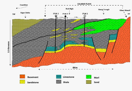
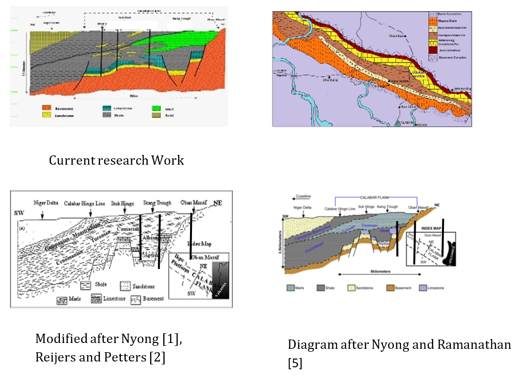
The Calabar Flank is a diminutive Nigerian sedimentary basin; a fringe which forms on the edge of the Gulf of Guinea. The major difference between the Calabar Flank and the southern Benue Trough resulted from the initial rifting of southern Nigeria margin which led to the formation of two principal sets of faults, the NE-SW and the NW-SE trending sets of faults characterize the Benue Trough and the Calabar Flank respectively [3]. Murat [3] defined the tectonic components of the Calabar Flank to include the Ikang Trough and the Ituk High which were a mobile depression and stable mobile submarine ridge respectively. Nyong and Ramanathan [5] have shown that the Calabar Flank is underlain by horsts and graben structures (Figure 3).
The Ekenkpon Shale is derived from mainly felsic rocks having mainly clay minerals and formed in passive to tectonic settings. It was deposited in an oxic, continental to transitional marine environment [8]. According to Itam, et al. [9], the Ekenkpon Shale has been deposited under the influence of arid to warm climate, marginal marine setting using recovered palynormorph assemblages.
Materials and Methods
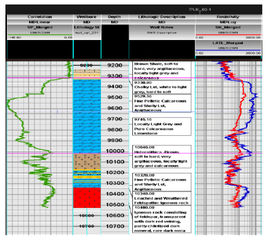
Materials used for this study are seismic, well logs, location map and mud log data. The well logs (A, B, C) that were drilled at different periods within the study area. The logs analyzed and used in this work include Gammar Ray (GR) log, Self-potential (SP) log, Resistivity log, Neutron and density logs. The logs signatures were interpreted and described of the study area. This study was carried out by comparing the surface Ekenkpon Shale evaluated by studies with its subsurface equivalent and this work. The procedure adopted in carrying out this study involved lithology identification, lithologic description and facies distribution using well logs, processed seismic and mud log data.
Results and Discussions
Well Logs Analysis
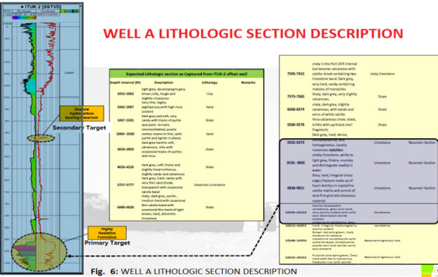
The Gammar Ray log and SP Logs signatures were interpreted delineated facie types such as shale, sand and carbonates in the studied wells. The Resistivity log was used to interpret fluids types while the Neutron and Density logs were used for Porosity and fluid type identification (Figure 6 and Figure 5). The interpreted log sequences were used to match lithologic sequences and interpreted seismic data for measure of equivalence (Correlation).
Regional Well by Well Correlation
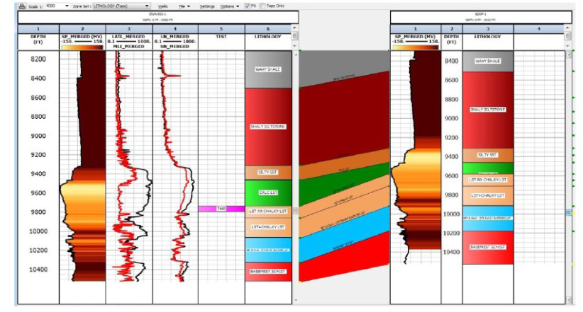
The Facies types such as shales, sands, marl and carbonates were inferred from ditch cuttings description and log signatures (Figures 4-7). The identified facies were correlated laterally across the studied wells to establish continuity and subsurface facie distribution within the regional framework and localized well placement.
Correlation of Lithostratigraphic Units
Stratigraphic correlation shows the continuity and pinch out of the different facies, and the equivalence of stratigraphic units in the study area. The lithostratigraphic units were delineated in vertical succession by surfaces representing the changes in lithologic characters, such as showing regressive or transgressive sequences and the different sedimentary facie type deposited in the field. During correlation process, a modified method of lateral continuous line tracing and use of broken lines for area of uncertainty of lithostratigraphic units is employed for accurate correlation. Individual units were traced from well to well.
Well to Seismic Tie
A seismic to well tie was built from the key horizon’s wells of Wells A, B and C and a tie was achieved. Lithologic description carried out to showed its matching relationship with the wireline log signatures and the ditch cuttings descriptions obtained for each penetrated level. Based on this, a composite stratigraphic section was produced by matching seismic attributes with well and mud logs to establish facie types, facie distribution and the lateral facie extent in the study area.
Facies Environment of Deposition
Various facies identified in this work are based on new information on – seismic, well log and lithological data which was not available to previous researchers in the study area which previous researchers relied to predict subsurface facies distribution in the study area. The identified facies in chronological order comprise arkosic sandstones of the Awi Formation deposited in a Fluvio-Deltaic environment during the Aptian Transgressive and Regressive cycle. The Albian Mfamosing Limestone (Organic and marine in origin), the Cenomanian Ekenkpon Shale with calcareous mudstones and oyster beds (Organic and marine in origin) and Coniacian New Netim Marlstone marine in origin. The Maastrichtian Nkporo Shale is shallow marine made up of carbonaceous shale, mudstones and gypsum (Table 1).
| Age | Formation | Depositional Environment | Wells that Penetrated the Formations |
|---|---|---|---|
| Campanian- Maastrichtian | Nkporo Shale | Shallow - Marine | Wells A, B, C |
| Santonian | Santonian Episode | No Deposition | |
| Coniacian | New Netim marl | Marine | Only Well C |
| Cenomanian - Turonian | Ekenkpon Shale | Marine | Wells A, B. C |
| Albian | Mfamosing | Marine | A, B, C |
| Aptian | Awi Formation | Fluvio-Deltaic | A, B, C |
| Precambrian | Oban basement |
Table 1: Stratigraphic sequence of the Calabar Flank (Lower Benue Trough) with wells that penetrated each section.
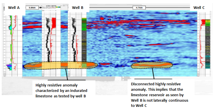
The current structural and subsurface representation of the study area in terms of facies types, their distribution and lateral extent was compared with previously published works earlier established by Nyong and Ramanathan [5], Nyong, Reijers and Petters [11] with a view to review the subsurface geology of the study area (Calabar Flank) (Figures 8 & 9). Previous work by Nyong and Ramanathan [5], Reijers and Petters [2] on the structural setting and subsurface distribution of Cretaceous sequences in the Calabar Flank was illustrated by placing same wells used in this study (wells A, B and C) on each of their cross-sectional profile (Figure 8) and the identified facies correlated across the studied wells (Figure 8). Correlations after Nyong [1], Reijers and Petters, [2] shows as the wells were superimposed on their works, Well A penetrated the Awi Formation, Mfamosing Limestone, Netim Marlstone, and Nkporo Shale. Well B penetrated the Awi Formation, Mfamosing Limestone, Ekenkpon Shale, Netim Marlstone and the Nkporo Shale while Well C penetrated only Awi Formation, Mfamosing Limestone and Netin Marlstone. The Ekenkpon Shale observed based on their work, well B pinched out before getting to well A and well C NE and SW of the Calabar Flank respectively. The Nkporo Shale also pinched out towards SW of the study area before getting to well C. The wells all penetrated the Awi Formation, Mfamosing Limestone and the Netim Marlstone only. The correlation after Nyong and Ramanathan [5] shows almost the same sequence with that of Reijers and Petters [2] however differed slightly with respect to in the extension of the Ekenkpon Shale. The Ekenkpon Shale only pinched out towards the NE of the Calabar Flank before getting to well A but extended through to the SW of the Calabar Flank getting to well C. The analyses by previous works were dependent on surface outcrop studies whereas current study relied on well log and seismic data to modify the subsurface distribution of Cretaceous facies in the study area (Figure 7, 8). The stratigraphic correlation of the lithologic units across the three wells drilled in the Calabar Flank shows the same correlatable sequence for well A and B while well C has a slightly different sequence (Figure 7, 8 and Table 1). Well C has marlstone overlying the Ekenkpon Shale which pinched out before getting to well B see Figure 8. The stratigraphy as depicted in established an extensive sequence of the Ekenkpon Shale from the SW to the NE of the Calabar Flank (Figure 7) which is in agreement with this work.
Summary and Conclusions
Previous works on Ekenkpon Shale were conceptual illustrations of the subsurface based on surface outcrop studies however, this work is data driven based on seismic, well log and core data which modifies the subsurface Ekenkpon Shale in the study area. Juxtaposing the structural and subsurface geological setting from the findings of this work against previous works it is evident that the lithostratigraphic sequences are not correlatable and differ especially in the distribution of facies such as Ekenkpon Shale, their lateral extents and their structural settings. The Ekenkpon Shale was only seen by well C in the as identified by Nyong and Ramanathan [5], Reijers and Petters [2] however this study reveals that the three wells penetrated the Ekenkpon Shale. This implies that the Ekenkpon Shale extended through wells A NE to well C SW of the study area and did not pinch-out as opined by previous works.
References
-
Nyong EE (1995) Cretaceous sediments in the Calabar Flank. In: Ekwueme BN, et al. (Eds.), Geological excursion guidebook to Oban Massif, Calabar Flank and Mamfe Embayment, Southeastern Nigeria. Nigeria Mining and Geosciences society 31st Annual Conference, Calabar, pp: 14-25.
-
Reijers, TJA, Petter SW (1997) Sequence stratigraphy based on microfacies analysis: Mfamosing Limestone, Calabar Flank, Nigeria. Geolos en Mijnbouw 76: 197-215.
-
Murat RC (1972) Stratigraphy and paleogeography of the Cretaceous and Lower Tertiary in Southern Nigeria. African Geology, University of Ibadan, Nigeria, pp: 251- 266.
-
Adeleye DR, Fayose EA (1978) Stratigraphy of the type section of Awi Formation. Journal of Mining Geology 15: 30-57.
-
Nyong EE, Ramanathan R (1985) A record of oxygen- deficient paleoenvironments in the Cretaceous of the Calabar Flank, SE Nigeria. Journal of African Earth Sciences 3(4): 455-460.
-
Edet JJ, Nyong EE (1993) Depositional environments, sea level history and paleobiogeography of the Late Campanian-Maastrichtian on the Calabar Flank, SE Nigeria. Palaeogeography, Palaeoclimatology, Palaeoecology 102(1-2): 161-175.
-
Reyment RA (1965) Aspects of the Geology of Nigeria. Ibadan University Press, Nigeria, pp: 145.
-
Mathew EN, Oto SA, Olajide JA (2018) Geochemistry of Ekenkpon and Nkporo Shales: Implications for Provenance Transportation History and Depositional Environment. Global Journal of Geoscience 16: 63 -78.
-
Itam AE, Una EF, Udoh MU, Inyang DO, Emeka CN, et al. (2019) Palynological evaluation of cretaceous sediments of Ekenkpon Shale, Calabar Flank SE Nigeria. Journal of Scientific and Engineering Research 6 (7): 156-164.
-
Petters SW, Zaborski PMP, Essien NU, Nwokocha KD, Inyang DO (2010) Geological excursion guidebook to the Cretaceous of the Calabar Flank, Southeast Nigeria. Nigerian Mining and Geosciences Society 46th Annual Conference Shamber Grafitech Studio, pp: 28.
-
Petters SW, Nyong EE, Akpan EB, Essien NU (1995) Lithostratigraphic revision for the Calabar Flank. 31st Annual Conference of the Nigerian. Mining, Geoscience Society, pp: 54.
- Nigeria’s Vulnerability in the Face of Global Energy Policy
- A Simulation Study of Investigation of Optimum Oil Production Performance by Applying Various Gas Injection Methods in Oil Reservoir
- Characterization of Permo-Triassic Reservoirs through Thermal Maturity Assessment of Westphalian Source Rocks in the Cheshire Basin
- Influence of Microwax on the Rheological and Thermal Behaviour of a Wax Crude Oil
- Real-Time Monitoring and Performance Optimization of Steam Injection in Heavy Oil Reservoirs Using Fiber Optic Sensing and Integrated Predictive Simulation Models
- Rapid On-Site Determination of the Total Petroleum Hydrocarbon Content of Soils by Handheld Fourier Transform Near-Infrared Spectroscopy: Development of a Global, Site- and Scanner- Independent Calibration Model