Analyzing of Flow in Open Channels Networks Using HEC-RAS
This article shows a pliable unified modeling scheme applying a materially based, distributed, integrated hydrological and water quality modeling organization. It is need to analyze the unsteady flow in open channels network is done using the computer packages, because solving the Saint-Venant equation is very difficult and sophisticated spatially for a network of channels. The unsteady flow can be analyzed by Saint-Venant equations. These equations can be solved by characteristics and finite difference methods. The HEC-RAS program applies the second method. This program need to data such as: scheme of network channels, geometric properties of cross sections, initial discharge and boundary condition. The outputs of this program are: Surface profiles, flow hydrograph and distribution of flow velocity in each cross section etc. In this research an example was solved in unsteady flow using HEC-RAS. In this procedure, the energy and duration equations are decided for steady, slowly diverse flow by the Newton–Raphson procedure and the offered methodology is used to tree-type and looped-channel networks. An algorithm is introduced to define numerous critical depths in a compound channel. Corrections in channel geometry are provided to prevent the incidence of, many critical depths. The incidence of only one critical depth in an implicate cross section with improved geometry is shown for a tree-type channel network.
Introduction
The Saint-Venant fundamental equations (or Saint- Venant's principle), first presented in 1871, present a complete form of the governing forces of the flow. Solving these equations, especially in a network of canals or open channels with irregular sections, is a very complex and time taking task [1]. It is compulsory to use computer models and programs. By using such models, profile of water levels can be plotted in each branch of the channel network at any time. Also, the flow of hydrograph can be anywhere gained from the network [2]. The flow graph shows the current fluctuations in flow changes relative to time, which is the reason for such changes there may be several factors, including changes in the input to the grid, flood into the river, or breaking of the dam [3]. One of the models in this area is the FLDWAV model, which is the result of three decades of efforts by National Center experts American
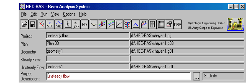
Figure1: Hydrologic Engineering Center's River Analysis System (HEC-RAS)
• The home screen of this application is displayed. An
unreliability analysis of the unsteady flow component of the one-dimensional model HEC-RAS within the universal chance unreliability assessment is introduced [7]. However, this relies on the model area and boundary situation. The urgency to identify between beneficial parameters and actual physical parameters is stricted [8]. The research shows that this analysis can be applied to generate dynamic possibility maps of flooding during an occurrence and can be linked to a stopping standard for universal probability unreliability approximation [9]. This task explains the Journal of Ecology & Natural Resources
and accredit a Hydrologic Engineering Center's River Analysis System (HEC-RAS) river network model of the system applying available HEC-2 model-generated data [13]. Then, HEC-RAS simulations were maded to produce water surface profiles all over the system for six various design storm incidents [14]. ArcView GIS was coupled with HEC-RAS to generate a flood map for flood discharge of several return intervals [15].
Materials and Methods
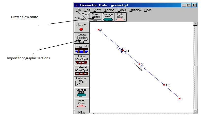
The steps in working with RAS-HEC are as follows: 1. Draw an open-loop network and enter geometric specifications of different sections of the network (Data Geometric / Edit: (This Specifications include cross section topography, manning roughness coefficient and length of sections of the section. (figure 2)
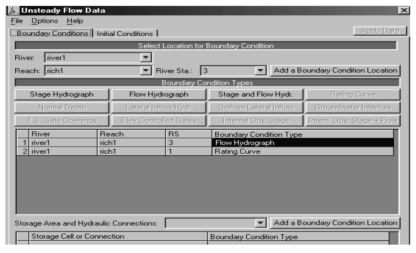
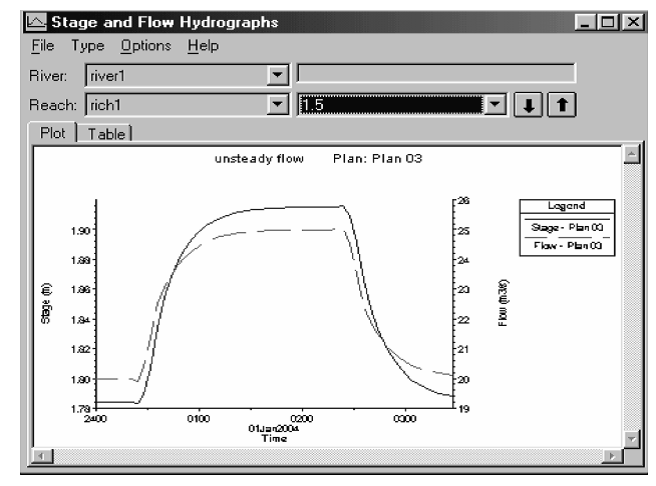
2. Entering current data (lasting or non- continuous) (data flow an unsteady Edit (This information includes upstream and downstream conditions and initial flow conditions [16]. Upper boundary conditions can be one the flow hydrograph and lower boundary conditions can be the flow curve (Figure 3)
Journal of Ecology & Natural Resources
3. Run the program (analysis flow unsteady: / Run :). To run the program, you must start the startup time and start it Completion of computations and intervals of computational steps (Figure 4).
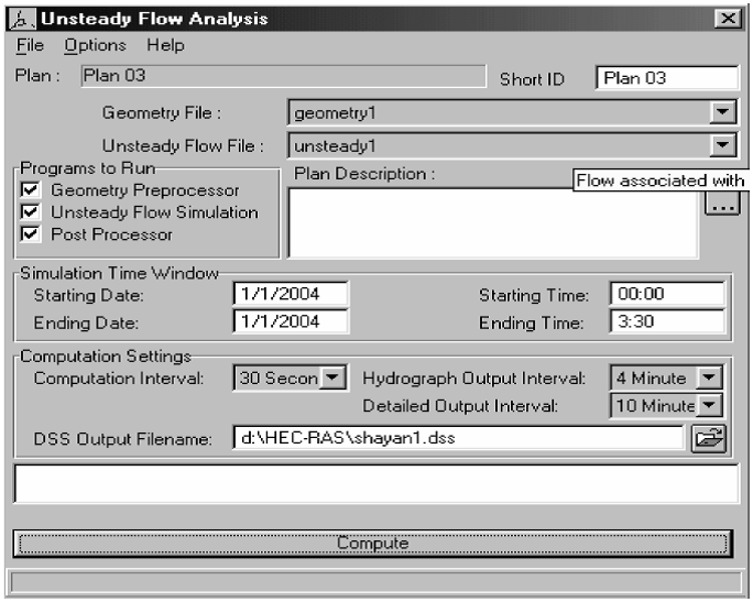
Figure4: Run program of HEC-RAS.
Results and Discussions
The information about a piece of a channel with the length of 2 km which starts with the flood of specific hydrograph and ends in a spillway is put in the model. The results are visible in the view option. The result
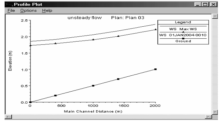
Journal of Ecology & Natural Resources
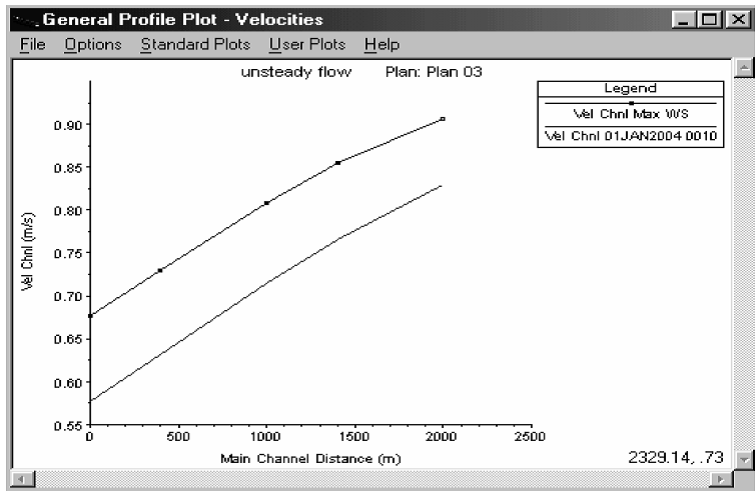
the hydraulic and geometric specifications of the main channel and floodplains [17]. As contrasted to the existing procedures, the methodology is more common and appropriate for usage to compound and trapezoidal Journal of Ecology & Natural Resources
channel cross parts in series channels, tree-type or looped networks.
Conclusion
Multiple hydrological studies have be seen that river discharge evidences are affected by considerable unreliability. This hesitancy is envisaged to be very high for river flow data referred to flood incidents, when the stage–discharge rating curve is extrapolated far beyond the module limit.This reading inspects the standard methodologies for the building and extrapolation of rating curves to excessive flow depths and depicts to require of suitable techniques to decrease the indecision of flood discharge data. Consequences received with HEC-RAS model were applied in compound with ArcGIS to provide floodplain maps for variant return cycles. The very different flow regime of River is determined by frequent floods with cautiously expanding and sometimes terrified peak water levels and by repeated, long-lasting low flows. The primary causes of these features are: the form of drainage basin; the discharge of tributary streams related to the one of the main channel; the high sediment transport; the low slope of the low-land reach and the tought low-flow and high-flow river channel. Routing is a procedure applied to simulate and auspicate alters in water flow along a river or channel. There are multiple hydraulic flow routing procedures that model channel flow with great precision applying lots of data related to channel geometry and specifications, so making computations very costly. In difference, hydrologic procedures are methods that clarify the computation of flow situations in a channel reach. Routed hydrographs for ordinary and composed channels are then contrasted with a river analysis system model (HEC-RAS). Those consequences show that the suggested model (HEC-RAS) procedure is beneficial in routing a stage hydrograph.
References
-
Fread DL, Lewis JM (1986) Parameter optimization of dynamic routing model, proceedings, Water forum 86: World Water Issues in Evolution, ASCE, Long Beach, CA, 443-450.
-
Fread DL, Lewis JM (1988) FLDWAV: A generalized flood rovting model, proceeding of Nation al Conference on Hydraulic Engineering, Spring, Colorado, 6pp.
-
Fread DL (1993) NWS FLDWAV Model: The replacement of DAMBRK for dam-break flood predictro, proceeding loth Anval coference of the Association of state dam safty officials, Inc., Kansas city, 177-184.
-
HEC.U.S Army (2001) Manual of HEC-RAS. DOI: www.hec.usace.army.mil/software/hec- ras/documentation/HEC-RAS 5.0.
-
Pappenberger F, Beven K, Horritt M, Blazkova S (2005) Uncertainty in the calibration of effective roughness parameters in HEC-RAS using inundation and downstream level observations. J Hydrology 302(1-4): 46-69.
-
Leticia B, Rodrigueza PA, Cellob C, Vionneta A, David G (2008) Fully conservative coupling of HEC-RAS with MODFLOW to simulate stream–aquifer interactions in a drainage basin. J Hydrology 353(1- 2): 129-142.
-
Kaveh Ostad-Ali-Askari, Mohammad Shayannejad (2015) Usage of Rockfill Dams in the HEC-RAS Software for the Purpose of Controlling Floods. American Journal of Fluid Dynamics 5(1): 23-29.
-
Knebl MR, YangaK ZL, Maidment R (2005) Regional scale flood modeling using NEXRAD rainfall, GIS, and HEC-HMS/RAS: a case study for the San Antonio River Basin Summer 2002 storm event. J Environ Manag 75(4) 325-336.
-
Yang J, Ronald DT, Bahram D (2006) Applying the HEC-RAS model and GIS techniques in river network floodplain delineation. Canadian J Civil Eng 33(1): 19- 28.
-
Prashanth Hr, Hanif CM, Jasim I (2014) Computation of gradually varied flow in compound open channel networks. Sadhana 39(6): 1523-1545.
-
Giuliano DB, Pierluigi C (2011) A hydraulic study on the applicability of flood rating curves. Hydrology Res 42(1): 10-19.
-
Muhammad SK, Faizan A, Tariq US (2016) Floodplain Mapping Using HEC-RAS and ArcGIS: A Case Study of Kabul River. Arabian J Sci Eng 41(4): 1375-1390.
-
Mohsin JB, Muhammad U, Raheel Q (2013) Landslide dam and subsequent dam-break flood estimation using HEC-RAS model in Northern Pakistan. Nat Hazards 65(1): 241-254.
-
Sandor K, Attila K, Janos S (2006) Experiences in Application of Hec-Ras Model Under Circumstances Journal of Ecology & Natural Resources Of Flood Waves. Flood Risk Management: Hazards, Vulnerability and Mitigation Measures pp 47-58.
-
Fallah-Mehdipour E, Bozorg HE (2013) Application of Genetic Programming in Stage Hydrograph Routing of Open Channels. Water Resources Management 27(9): 3261-3272.
-
Vaze J, Teng J, Spencer G (2010) Impact of DEM accuracy and resolution on topographic indices. Environ Modeling Software 25(10): 1086-1098.
-
Brunner GW (2010) HEC-RAS, river analysis system hydraulic reference manual. US Army Corps of Engineers Hydrologic Engineering Center (HEC), 609 Second Street Davis, Ca 95616-4687.
- Lessons to Learn: Trees are More than the Lungs of the World
- Community Forestry Enterprises as a Model for Sustainable Forest Development: The Case Of The "Baja Tarahumara" in Chihuahua, Mexico
- Ecological and Socio-Economic Impacts of Chromolaena odorata and Mesosphaerum suaveolens, Two Invasive Alien Species in Central and Southern Benin, West Africa
- Epigenetic Sustainability: Modeling the Human Factor as a Natural Resource through Science 4.0 and the NR3C1 Biological Pilot
- Growth-at-Risk: A Framework for Assessing Economic Vulnerability
- The Rural Territory as a Socioecological System for the Management of Public Policy for Sustainable Rural Development