Indigenous Farmers’ Responses to Climate Change on the Bui Plateau of Cameroon
African farming societies have always survived changing environmental shocks. Enhancing indigenous capacity is key to effective participation in the development process in the era of global climate change. Inadequate information flow between farmers and weather scientists has brought ethno-meteorological knowledge to the limelight for climate change adaptation in rural areas. This study assesses indigenous farmers’ responses to climate change on the Bui Plateau. Data sources included field observations and questionnaires (N=597) in the seven agroecological basins of the Bui Plateau. Results showed that farmers make informed decisions on cropping cycles based on the behaviour of plants and animals, consultation of local weather seers, and community leaders and the behaviour of streams. Traditional responses may not adequately address climate change uncertainties, but they can lead to sustainable responses in the longer term. Instead of using indigenous knowledge solely or neglecting it, its integration into climate change policies can lead to cost-effective adaptation. Indigenous knowledge delivers appropriate entry points for climate change adaptation.
Introduction
Climate variability and change compromise the ability of rural farmers to satisfy needs inherent to the environment [1]. Although environmental changes have occurred over generations, rural farmers have adapted using local knowledge [2]. Indigenous knowledge is a readily available climate-smart tool for sustainable development and the management of climate variability [3]. Environmental problems vary over space and time [4], but rural farmers, through continued trial and error, and sustained interactions with the local environment, have developed a wealth of knowledge about nature in their locale that they use in coping with and solving their climate-related problems [5].
‘Indigenous knowledge’ (IK) is often used to describe the ideas developed by a community as opposed to the scientific or ‘modern knowledge’ [6, 7]. It is the basis for local- level decision-making in many rural communities [8]. It is valuable for the culture and scientists and planners striving to improve the well-being of rural areas [9]. Incorporating IK into climate change policies can lead to cost-effective, participatory and sustainable adaptation [10]. IK, a complex and cumulative body of facts, practices and representations, is preserved and advanced by people with prolonged histories of connections with the natural environment [11]. These systems are complex and include attachment to place, language, perception of worldview and spirituality [12].
Knowledge, practices and innovations of indigenous and local communities worldwide are rooted in experience and history [13]. IK is dynamic and adapts to environmental and cultural change, incorporating other perspectives and forms of knowledge [14]. IK is transmitted orally from generation to generation [11]. Local communities in Sub-Saharan Africa have developed intricate systems of gathering, predicting, interpreting and decision-making about the weather [15]. Farmers use knowledge of weather systems such as rainfall, thunderstorms, windstorms, harmattan and sunshine to prepare for future activities [16]. Elderly farmers frame propositions about seasonal rainfall by observing natural phenomena, while ritual and cultural specialists draw forecasts from predictions, and visions [17]. The most reliable indicators are the intensity, timing and duration of low temperatures during the beginning of the dry season [7]. Other forecasting indicators include the timing of fruiting of certain local trees, the water level in ponds and streams, the nesting and migratory patterns of birds and insect behaviour in waste heaps [9].
Sub-Saharan African cultures encompass an informal institution of ‘rainmakers’ who would not as much invoke rains, but predict them based on ethnic meteorology (an indigenous way of forecasting and interpreting weather conditions) [18, 8]. Globalisation has eroded the knowledge system of community people to the extent that these local curators are branded as ‘backward charlatans’ [12]. Apart from the stigmatisation and labelling experienced by small farmers, abrupt changes in weather patterns, which also interrupt natural indicators used in ethno-meteorology, continue to overwhelm the smallholders in their present environments [19]. More than ever before, smallholders are now consistently susceptible, making them more socio- economically miserable [20]. Regardless of the current influx of scientific weather forecasts, smallholder farmers are deeply entangled in the complexities of climate variability and climate change [18]. In the phase of these mounting environmental crises, this study aims to assess indigenous farmers’ responses to climate change on the Bui Plateau.
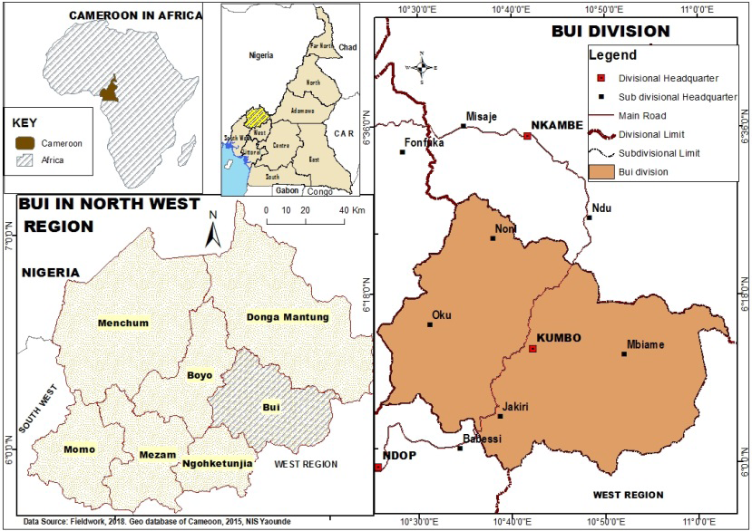
Study Area and Methodology
The Bui Plateau of the Bamenda Highlands of Cameroon has seven micro agro-ecological zones situated between latitudes 6o00”-6o20″N and longitudes 10o30″-10o60″E (Figure 1). Bui is an orographic plateau within the Cameroon Volcanic Line (CVL) with spectacular landscapes like Mount Oku (3,011 masl) and the Mbaw–Tikar Plains (≈710 masl). It provides a major watershed for the Niger and Sanaga river systems (Tume and Fogwe, 2018). The area has a surface area of about 2,795 km2. Administratively, this area covers Bui Division, with headquarters in Kumbo, covering six administrative units: Kumbo (630 km2), Jakiri (675 km2), Nkum (375.3 km2), Nkor–Noni (307.7 km2), Mbiame (575 km2) and Oku (232 km2).
The Bui Plateau is diverse and segmented into seven agrarian basins, which do not respect administrative boundaries, necessitating the administration of questionnaires in clusters. The principle of cluster sampling solves the problem of data collection in a culturally and physically diverse area. A convenient way to take a sample is to divide the area into smaller overlapping areas and then randomly select some smaller areas (households located in the agroecological basins). In cluster sampling over the Bui Plateau, the target population were rural farmers.
These were subdivided into relatively smaller units relating to crops which are grown in specific areas. In cases where more than one crop dominates in an agro-basin, double or multiple levels of clustering were applied (multi- stage cluster sampling). A total of 597 questionnaires were administered (Table 2).
| Administrative units | Population | Agro basins | Questionnaires | ||
|---|---|---|---|---|---|
| Population | % | F | % | ||
| Kumbo | 127,919 | 22.35 | Nkar-Kumbo-Kikaikom | 94 | 15.7 |
| Jakiri | 59,951 | 10.47 | Mbokam-Ngomrin-Mbaw Nso | 68 | 11.4 |
| Nkum | 127,538 | 22.28 | Dzeng-Tatum-Banten | 91 | 15.2 |
| Nkor-Noni | 63,487 | 11.09 | Djottin-Nkor-Lassin | 81 | 13.6 |
| Elak-Oku | 144,800 | 25.30 | Oku-Vekovi-Tadu | 105 | 17.6 |
| Mbiame | 48,684 | 8.51 | Mbiame-Nkuv-Ndzeen | 158 | 26.4 |
| Total | 572,379 | 100 | Total | 597 | 100 |
Table 1: Population of the Bui Plateau and administration of questionnaires.
The Nkar-Kumbo-Kikaikom agro basin covers most villages in Kumbo Central, Dzekwa area, the middle belt of Jakiri Sub-Division, extending down to Wainanmah. The Ngomrin-Mbokam-Mbaw Nso Plain covers the southeastern part of the Jakiri Sub-Division, extending northeast into the Mbiame Sub-Division and thrusting eastwards into the Ndop and Tikar plains. Oku-Vekovi-Tadu basin covers the highland montane communities of Jakiri Sub-Division like Kinsenjam and Vekovi, extending across to Kaiy, Taashem and Vivem in Kumbo Central Sub-Division. It extends westward to cover all of the Oku Sub-Division. The Dzeng-Tatum-Banten basin covers much of the Nkum Sub-Division. It extends north- westward into the Noni Sub-Division. From the Dzeng Plateau, it shares boundaries with Mbiame and covers the rugged terrane of Yangkitari, which is a northern extension of the Kov Ndzeen range in Kumbo Central Sub-Division. Nkuv-Ndzeen basin covers the southeastern part of Kumbo Central. It is a rugged frontier, which is reputed for massive deforestation, overgrazing, cropper-herder conflicts, landslides and fast-flowing streams. The Djottin-Nkor- Lassin Plain is located at the northwest edge of the Plateau. It extends northwards into the Donga plain. The Mbiame basin is situated between the Mbaw Nso Plain and Dzeng. It can be described as a transitional ecological zone because of a mixture of highland and lowland climatic characteristics.
Results
The dearth of meteorological data in the Bamenda Highlands necessitates the use of indigenous perceptions. The indicators include sources of weather activities and local weather information, farmers’ knowledge of weather forecasting, farmers’ perception of the nature of local and scientific weather knowledge, perception of climate variability, and perception of factors influencing indigenous environmental knowledge and practices. It is assumed that indigenous knowledge is a more dependable source of weather and environmental knowledge than conventional sources on the Bui Plateau.
Sources of Indigenous weather knowledge
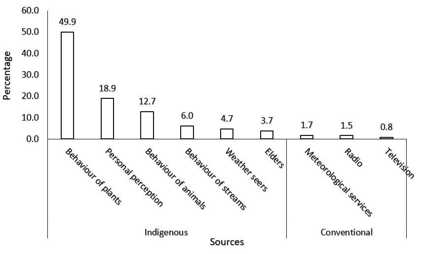
Sources of Indigenous weather activities on the Bui Plateau are through the behaviour of some plants (49.4%), personal intuitive perception (18.9%), the behaviour of some animals (12.7%), consultation of traditional weather seers (4.7%), the behaviour of streams (6%) and consultation of community elders (3.7%). A small proportion of inhabitants of the population of the Bui Plateau uses conventional sources such as television, (0.8%), meteorological services (1.7%), and radio (1.5%) (0.5%) (Figure 2). The dominance of indigenous sources of weather activities is because most farming communities do not have access to electricity, which deprives them of gadgets like televisions and other electronic devices.
Farmers in frontier basins like Lassin, Mbaw Nso, Nkuv, Gwarkang, Mbokam and Njanawa use mainly simple phones (for those who can afford them) charged with small solar panels. This is partly why such farmers resort more to indigenous sources of weather activities than scientific weather information. Indigenous farmers reported about 47% that the language of conventional weather forecasting is too complex and hard for them to understand. They also asserted that the situation is worsened by the absence of weather scientists (37%) to inform them about weather variations for agricultural planning. Rural farmers also asserted that scientific weather is faulty (9%) and hardly correspond to observed realities and it is communicated sporadically through local radio and television channels (7%). With these limitations of conventional weather sources, farmers rely on community elders (45%), personal weather observation (27%), local weather seers (24%), friends and other farmers (3%).
Local weather seers and community elders often invoke the gods of the rain through periodical incantations and traditional sacrifices. In Nso land for example, such traditional sacrifices are performed at the beginning of the planting season, where the ‘gods’ are invoked for a good growing season, before the first weeding, harvesting and farming season. The first sacrifices are performed by the Fon (King) of Nso at five shrines: the palace in Kumbo, Mantum (Jakiri), Kinsaan plunge pool (Kitiwum), Mairin plunge pool (Takui) and the palace in Kovifem. After the fon’s performance, other traditional leaders do the same in their respective areas of authority. Such sacrifices involve pouring libation, invocations and slaughtering goats and chickens, where their blood is sprinkled as a sacrifice. The slaughtered animals are not edible by anyone. Their carcasses are allowed in the open to be devoured by vultures and other animals.
Community knowledge for agrarian weather forecasting
Community knowledge of weather forecasting is an important component of ethno-meteorology. It is based on traditional ecological knowledge handed down from generation to generation. Several indicators were used in this study to express indigenous community knowledge for planning agricultural activities (Table 2).
| Indicators | % |
|---|---|
| Discerning whether there will be excess or scarce rains in a given farming year | 41.9 |
| Forefathers from whom the farming experience was acquired | 70.7 |
| Build of rain clouds | 95.5 |
| Mere smells | 51.4 |
| Necessary decisions to overcome any weather problems | 51.3 |
| Personal experience | 72.2 |
| Predicting extreme temperatures in a given farming year | 55.9 |
| Sounds of birds and insects | 73.7 |
| Star constellation, predict whether it will rain or not | 60 |
| The pattern of early rains in a farming year | 55.6 |
| The sequence of yearly weather events in a farming season | 42.9 |
| Through certain plants | 49.6 |
This is because conventional weather services are relatively absent, with only three functional stations (as of 2023) (Takui, Shisong, Jakiri). With increasing uncertainty of first rains, most decisions made by indigenous farmers on the Bui Plateau are based on personal experience and conviction (72.2%). As risky as such decisions at the beginning of the planting may be, farmers perceive that the behaviour of rains at the onset of the wet season gives them a clue as to how the rest of the growing season will unfold. The erratic rainfall can cause misinformation and mislead farmers to make wrong decisions, given that the dry season is already gradually prolonged. Some signs such are mere smells (51.4%) that Indigenous communities rely on to predict whether it is going to rain or not at a particular time are still en vogue.
Some people are gifted to predict the onset of first rains through weather smells, especially in the mornings of February, March and April. The sounds of some insects and birds are common indigenous weather forecasting tools in many communities of the Bui Plateau (73.7%). One such bird is the Senegalese Cowcow, which sings in the morning or any time of the day to announce rains in about the next 10 to 60 minutes. Also, the prattling of the Cameroon Mountain Francolin indicates good weather. Insects like crickets cackling at night is an indicator that there will be no rain. Another visible indicator of cessation of the wet season is swarms of dragonflies that fly eastwards from October to November. In the absence of conventional weather forecasting, farmers in the Bui Plateau also read weather signs through the behaviour of some plants (Scadaxus multiflorous) (49.6%), (Figure 3), which blossoms only once a year in late February to early March. This plant has been used for generations in reading the onset of the first rains.
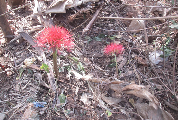
Once it blooms, the wet season will begin in about three to four weeks. Some farmers in Shisong affirmed that reading weather signs through the behaviour of plants and animals was handed to them by their great-grandfathers. IK handed by forefathers from whom they acquired farming experience has had long-standing and proven experience
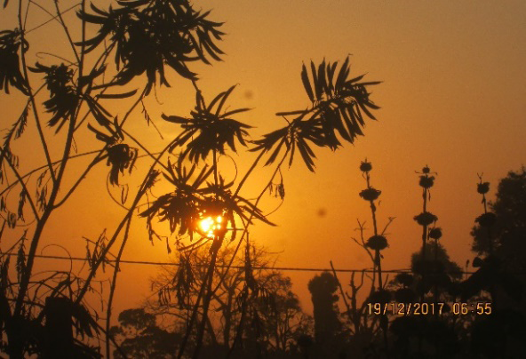
of weather forecasts from which they have profited. From such practices, farmers foresee rainfall patterns during the growing season. During the dry season, indigenous farmers also study the red-yellowish atmospheric aerosol loading to make decisions about their farming activities (Figure 4).
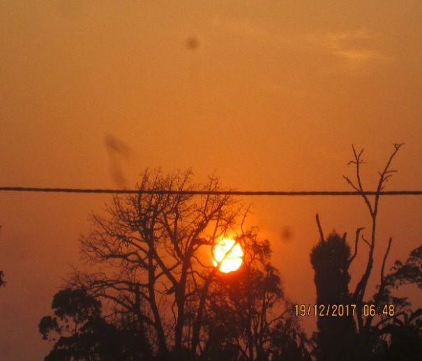
Aerosol colouring of the atmosphere occurs from December till the start of the rainy season. This colouring indicates the appropriate time for farmers to start raising ‘ankara’ on farms. Raising ankara is through the burying of maize stalks before burning. Ankara is also practised in newly opened fields. Bush burning for agricultural activities, pasture regeneration and dry season dust storms are the main sources of local aerosol loading into the atmosphere in the Bamenda Highlands of Cameroon during the dry season. From February, rain clouds (cumulo-nimbus) start building. Through the gathering of clouds (95.5%) such as a small alto-cumulus and strato-cumulus (Figure 5), community elders, weather seers and people with experience in reading weather signs can predict the exact date that the wet season begins.

Local weather knowledge in agrarian practices
A local farmer’s ability to make informed decisions is largely governed by personal experiences acquired over the years. In the absence of credible scientific weather information systems to farmers, they must resort to what is at their disposal. Even when scientific weather systems are broadcast on the media, they appear hard to understand by rural farmers because of low levels of formal education (Table 3).
| Variables | Yes | No | Undecided | |||
|---|---|---|---|---|---|---|
| F | % | F | % | F | % | |
| Both local & scientific knowledge in weather forecasting are produced through observation | 486 | 81.4 | 55 | 9.2 | 56 | 9.4 |
| Formal education or training is not needed to acquire skills in Indigenous weather forecasting | 418 | 70 | 59 | 10 | 120 | 20.1 |
| Local knowledge is simple to understand | 433 | 72.5 | 106 | 17.8 | 58 | 9.7 |
| Local knowledge of weather prediction does not require the use of sophisticated tools | 450 | 75 | 80 | 13 | 67 | 11.2 |
| Local weather predictions are more accurate for farming decision-making | 372 | 62 | 163 | 27 | 62 | 10.4 |
| Local weather reading entails great spirituality | 313 | 52 | 208 | 35 | 76 | 12.7 |
| Scientific knowledge in weather follows procedures; local knowledge is unregulated & haphazard | 439 | 74 | 88 | 15 | 70 | 11.7 |
| Scientific weather forecasting and local predictions are mutually exclusive | 346 | 58 | 174 | 29 | 77 | 12.9 |
| Scientific weather forecasting should only supplement Indigenous approaches | 318 | 53 | 160 | 27 | 119 | 19.9 |
| Scientific weather forecasts are faulty | 338 | 56.6 | 142 | 23.8 | 117 | 19.6 |
| Traditional knowledge of weather prediction requires no financial investments | 391 | 65 | 104 | 17 | 102 | 17.1 |
Table 3: Farmers’ perception of the nature of local and scientific weather knowledge.
Weather forecasts broadcast by local media such as Cameroon Radio Television (CRTV), Spectrum Television (STV) and Equinox TV are often not understood by rural farmers. Local weather knowledge is simpler to understand than conventional scientific knowledge. Both local and scientific knowledge in weather forecasting over the years is produced through observation, experimentation and validation. Scientific knowledge in weather reading follows certain procedures in its production process, but technology local knowledge is unregulated and haphazard or unorganised by oral tradition.
Changing Environmental Conditions in the Bui Plateau
The impact of anthropogenic activity on the Bui Plateau has been able to evolve and develop social structures, subject not only to great forces of nature and occasional perturbations of the delicate steady state of nature but also exposed livelihood and life support systems like ecosystem services to irreversible damages. In the 1970s, the agrarian system was characterised by flat ridging, high coffee prices, and massive deforestation to establish new farmlands and plant eucalyptus (Table 4).
| Period | Activities | Weather traits | Changes |
|---|---|---|---|
| 1970s | Flat ridging, massive deforestation, high coffee prices, planting of eucalyptus | Regular onset of first rains in mid-March | Abundant water resources; unperceived changes |
| 1980s | The decline in coffee prices, massive deforestation, the emergence of eucalyptus plantations, and massive elimination of coffee farms in the mid-1980s due to the slump of prices at the world market | Regular onset of first rains in mid-March, severe droughts | Abundant water resources; moderate changes |
| 1990s | The advent of the application of chemical fertilizers in the early 1990s | Irregular onset of first rains, high frequency of extreme weather events | Drop in stream volumes; moderate vulnerability |
| 2000s | Application of chemical fertilizers to boost crop production, emergence of cropper- herder conflicts | The irregular onset of early rains, frequency of extreme weather events (floods & droughts), increasing temperatures | Mounting water scarcity; high vulnerability |
| 2010s | Spray weeding, fast-maturing crops, intense application of chemical fertilizers, caterpillar invasions during early growing season | Uncertain weather patterns, irregular rainfall, swelling temperatures | Emerging water insecurity; severe vulnerability |
| Since 2020 | More seasonal crops (Solanum potato) | Irregular rainfall, plunging temperatures | Water & food insecurity; severe vulnerability |
Table 4: Farmers’ perception of agrarian evolution on the Bui Plateau.
There was the regular onset of the wet season in mid-March. Water resources were abundant. There were hardly noticeable environmental changes. With the drop in coffee prices in the mid-1980s, large-scale deforestation of natural forests and the emergence of large-scale eucalyptus plantations. With the fall in coffee prices, farmers eliminated their coffee farms and transformed them into eucalyptus plantations and farmlands in the mid-1980s. Rainfall was regular with the onset first rains in mid-March. The drought of 1983-84 caused agitation in farming communities. With these, there were no major changes in water resources.
The drought of the early and mid-1980s caused minor environmental changes like a drop in crop production. From the 1990s, there was already a remarkable drop in food production, which initiated the advent of chemical fertilizer application. The onset of the first rains became irregular and extreme weather events like dry spells, stormy weather and floods increased. In July 1998, hail stones destroyed crops all over Bui. Water levels dropped remarkably in local streams. The inhabitants could already perceive that their livelihoods were vulnerable to changing environmental conditions. Civil society organizations introduced eucalyptus replacement to save watersheds. From the 2000s, reasonable food crop production for maize could only be boosted by the application of chemical fertilizers. Temperatures plunged and the onset of the first rains became very irregular. Mounting water scarcity became a daily reality, leading to the emergence of water scarcity problems. The onset of the Anglophone crisis in 2016 has aggravated the climate crisis as some communities are on the verge of food and water insecurity.
Discussion
Indigenous and local practices (ILP) are an outcome of the application of context, culture and location-specific knowledge to solve problems [1]. The close relationship of indigenous peoples with their environment makes them sensitive to the effects of ‘global warming’. Indigenous people tend to live in places that are worst hit by the impacts of environmental change and their poverty exacerbates vulnerability [21]. Local people make agrarian decisions based on perceptions of their environment through the behaviour of some plants, and animals, reading signs of the atmosphere and many other Indigenous environmental practices. In the Bui Plateau of the Bamenda Highlands of Cameroon, dark clouds, according to indigenes signify approaching heavy rain [6]. Ethno-meteorology is a mystery and only some members of the community are gifted in reading and interpreting cloud patterns [22]. Some of the predictions of ‘cloud watchers’ often miss out and can be very misleading because of changing climatic and environmental conditions.
Indigenous weather prediction does not require classy tools. Formal education or training is not needed to acquire skills in local weather forecasting [6]. Exercising local knowledge in weather prediction requires no financial investments. Despite gaping differences, scientific weather forecasting and local predictions are mutually exclusive. Local approaches to weather predictions are often accurate and as such are the best for making the right decisions in farming activities. Whereas scientific weather forecasting is purely secular, local knowledge of weather reading entails a great measure of spirituality. Indigenous peoples are among the first to face the direct consequences of climate change, owing to their dependence on and direct relationship with environmental resources [23].
Limitations arise on how both indigenous and scientific knowledge systems are viewed, which can increase the perceived inferiority of traditional knowledge to modern scientific knowledge [24]. Traditional knowledge is viewed to be closed, parochial, unintellectual, primitive and emotional, part of a residual, traditional and backward way of life, while contemporary knowledge is open, systematic and objective, centred on rationality and intelligence and centred within the developed world [5]. Whenever the two branches of knowledge are operating within the same environment, contemporary knowledge tends to dominate local traditional knowledge [6, 26]. Currently, it may be difficult to delineate what are local traditional farming methods per se because of current development interactions which may have caused much influence of the local farming practices with scientific practices [5]. This is because local small-scale farmers have contact with the scientific community (agricultural extension officers and NGOs) who may have influenced much of their knowledge system and practices, making it very difficult to disentangle the two farming practices due to their influences and similarities [27, 28].
Both indigenous and scientific knowledge have their limitations in providing informed solutions to social environmental management practices [6]. Nevertheless, both modern and indigenous traditional knowledge systems should complement rather than compete by incorporating respective economic, social and political perspectives that are useful and beneficial to the management of natural resources for the survival of the community [29]. Knowledge should be at the centre of creating solutions for some environmental problems, for it has evolved from the local community as opposed to scientific knowledge [25].
Traditional environmental knowledge has the advantage of being directly linked to household daily activities [30]. It is concerned with the immediate necessities of people’s daily livelihoods and can provide a short-term and immediate solution to a means of survival in the community, making it meaningful [31]. It may also be useful under transitory conditions, as opposed to contemporary science developed through research and principles for solving global problems without a local origin nor link to the social, cultural, political and physical environment of a specific local area and removed from the daily lives of the people [25]. Researchers acknowledge the dynamism of local knowledge in providing solutions and coping with new environmental and economic hardships in society [1, 5], with a further acknowledgement that some local farmers have succeeded in their farming systems by combining local farming methods with scientific knowledge [32, 33].
Conclusion
The dearth of meteorological data necessitates the use of indigenous perceptions. The sources of weather activities and local weather information, farmers’’ knowledge of weather forecasting, farmers’ perception about the nature of local and scientific weather knowledge, perception of climate variability, and perception of factors influencing indigenous environmental knowledge and practices. Key actions for integrating traditional and scientific climate change adaptation approaches in Cameroon could include demonstration projects in collaboration with rural and indigenous communities; action research on key concerns and issues; information and communication technologies to record, manage and transmit indigenous knowledge and know-how; training to build local capacities in relevant multimedia techniques and international workshops and seminars to promote reflection and dialogue. In responding and adapting to climate issues, there is a strong need to adopt integrated scientific, social science and traditional knowledge approaches. An integrated approach enables local communities to address current and projected climatic risks and to identify appropriate response solutions. Rather than using indigenous knowledge only, or discarding it completely, its incorporation into climate change policies can lead to the development of effective, cost-effective, and sustainable adaptation strategies. Indigenous knowledge provides suitable entry points for research and development on climate change adaptation practices.
References
-
Tume SJP, Kimengsi JN, Fogwe ZN (2019) Indigenous Knowledge and Farmer Perceptions of Climate and Ecological Changes in the Bamenda Highlands of Cameroon: Insights from the Bui Plateau. Climate 7(138): 1-18.
-
Gyampoh BA, Amisah S, Idinoba M, Nkem J (2019) Using Traditional Knowledge to Cope with Climate Change in Rural Ghana. Unasylva (60): 70-74.
-
Abeysinghe AC (2013) Addressing Climate Adaptation through Equity Concepts. International Institute for Environment and Development (IIED) Briefing, London, pp: 1-4.
-
Krishna V (2011) Indigenous Communities and Climate Change Policy: An Inclusive Approach. _The Economic,_ _Social and Political Elements of Climate Change._ Springer, Chan, 1.5.
-
Beckford C, Barker D (2007) The Role and Value of Local Knowledge in Jamaican Agriculture: Adaptation and Change in Small-scale Farming_._ Geographical Journal 173(2): 118-128.
-
Tume SJP, Kimengsi JN (2021) Indigenous and modern agro-based climate adaptation practices in rural Cameroon. International Journal of Environmental Studies 78(5): 1-10.
-
Ajani EN, Mgbenka RN, Okeke MN (2013) Use of Indigenous Knowledge as a Strategy for Climate Change Adaptation among Farmers in Sub-Saharan Africa: Implications for Policy. Asian Journal of Agricultural Extension, Economics and Sociology 2(1): 23-40.
-
Miller NP, Dow K, Tuler S, Webler T, Whitehead J, et al. (2014) Integrating Scientific and Local Knowledge to Inform Risk-based Management Approaches for Climate Adaptation. Climate Risk Management (4-5): 17-31.
-
Nakashima DJ, Galloway McLean K, Thulstrup HD, Ramos Castillo A, Rubis JT (2012) Weathering Uncertainty: Traditional Knowledge for Climate Change Assessment and Adaptation. Paris, UNESCO & Darwin, UNU, pp: 120.
-
Mafongoya PL, Jiri O, Mubaya CP, Mafongoya O (2017) Using indigenous knowledge for seasonal quality prediction in managing climate risk in Sub-Saharan Africa. In P.L., Mafongoya, O.C., Ajayi, (Eds.), _Indigenous_ _Knowledge Systems and Climate Change Management in_ _Africa,_ CTA, Wageningen, The Netherlands, pp: 43-66.
-
Hiwasaki L, Luna E, Syamsidik, Shaw R (2014) Local and Indigenous Knowledge for Community Resilience: Hydro-meteorological Disaster Risk Reduction and Climate Change Adaptation in Coastal and Small Island Communities. Jakarta, UNESCO, pp: 60.
-
Macchi M, Boedhihartono A, Wolfangel C, Howell M, Oviedo G, et al. (2008) Indigenous and Traditional Peoples and Climate Change. International Union for Conservation of Nature: 9-22.
-
Swiderska K, Malmer P (2016) Climate Change and Biocultural Adaptation in Mountain Communities: Second International Learning Exchange of the International Network of Mountain Indigenous People (INMIP). International Institute for Environment and Development, pp: 46.
-
Ramphele M (2004) Women’s Indigenous Knowledge: Building Bridges between the Traditional and the Modern. Indigenous Knowledge: Local Pathways to Development. World Bank, Washington D.C., pp: 13-17.
-
Chanza N, Mafongoya PL (2017) Indigenous-based climate science from the Zimbabwean experience: From impact identification, mitigation and adaptation. In Mafongoya P.L. & Ajayi, O.C. (Eds.) (2017): Indigenous Knowledge Systems and Climate Change Management in Africa, CTA, Wageningen, The Netherlands, pp: 67-94.
-
Ajibade LT, Shokemi O (2003) Indigenous Approaches to Weather Forecasting in Asa Local Government Area, Kwara State, Nigeria. Indilinga: African Journal of Indigenous Knowledge Systems 2(1): 37-44.
-
Roncoli C, Ingram K, Kirshen P (2001) The Costs and Risks of Coping with Drought: Livelihood Impacts and Farmers’ Responses in Burkina Faso. Climate Research (19): 119-132.
-
Kolawole DO, Wolski P, Ngwenya B, Mmopelwa G (2014) Ethno-meteorology and Scientific Weather Forecasting: Small Farmers and Scientists’ Perspectives on Climate Variability in the Okavango Delta, Botswana. Climate Risk Management (4-5): 43-58.
-
Emgeru A (2012) Role of Indigenous Knowledge in Climate Change Adaptation: A Case Study of the Teso Sub- Region, Eastern Uganda. Indian Journal of Traditional Knowledge 11(2): 217-224.
-
Briggs J, Moyo B (2012) The Resilience of Indigenous Knowledge in Small-scale African Agriculture: Key Drivers. Scottish Geographical Journal 128(1): 64-80.
-
Baird R (2008) The Impact of Climate Change on Minorities and Indigenous Peoples. Briefing: Minority Rights Group International, London, pp: 12.
-
Okonya JS, Ajayi OC, Mafongoya PL (2017) The role of indigenous knowledge in seasonal weather forecasting and planning of farm activities by rural crop farmers in Uganda. In Mafongoya, P.L. & Ajayi, O.C., (Eds.) (2017), Indigenous Knowledge Systems and Climate Change Management in Africa, CTA, Wageningen, The Netherlands, pp: 239-254.
-
United Nations Permanent Forum on Indigenous Issues- UNPFII (2008) Climate Change and Indigenous Peoples. Indigenous Peoples, Indigenous Voices, New York, pp: 3.
-
Tume SJP, Maghah JA (2021) Challenges to Climate Change Adaptation in the Agricultural Sector of Bui Division, North West Region, Cameroon. International Journal of Resource and Environmental Management 6(1): 55-68.
-
Briggs J (2005) The Use of Indigenous Knowledge in Development: Problems and Challenges. Progress in Development Studies 5(2): 99-114.
-
Mngumi J (2016) Perceptions of Climate Change, Environmental variability and the Role of Agricultural Adaptation Strategies by Small-scale Farmers in Africa: The Case of Mwanga District in Northern Tanzania. PhD Thesis, University of Glasgow, pp: 306.
-
Tume SJP, Banseka JY (2021) Stakeholders in Environmental and Climate Change Communication in the North West Region, Cameroon. African Journal of Social Sciences 12(7): 3-18.
-
Bollier D (2009) Protecting Indigenous Knowledge. _Electronic Journal of Indigenous Knowledge_ (12): 1.
-
Auty RM (2003) Natural Resources Development Models and Sustainable Development. International Institute for Environment and Development (IIED) Discussion Paper 3: 1-6.
-
Tume SJP (2023) Indigenous-led resilience in rural Cameroon. In Place-based capacity building to enhance resilience in tropical countries. One Earth 6(8): 935-938.
-
Niles MT, Mueller ND (2016) Farmer Perceptions of Climate Change: Associations with Observed Temperature and Precipitation Trends, Irrigation, and Climate Beliefs. Global Environmental Change 39: 133- 142.
-
Boansi D, Tambo JA, Muller M (2017) Analysis of farmers’ Adaptation to Weather Extremes in West African Sudan Savanna. Weather and Climate Extremes 16: 1-13.
-
Tume SJP, Fogwe ZN (2018) Standardised Precipitation Index Valuation of Crop Production Responses to Climate Variability on the Bui Plateau, Northwest Region of Cameroon. Journal of Arts and Humanities 1(2): 21-38.
- Lessons to Learn: Trees are More than the Lungs of the World
- Community Forestry Enterprises as a Model for Sustainable Forest Development: The Case Of The "Baja Tarahumara" in Chihuahua, Mexico
- Ecological and Socio-Economic Impacts of Chromolaena odorata and Mesosphaerum suaveolens, Two Invasive Alien Species in Central and Southern Benin, West Africa
- Epigenetic Sustainability: Modeling the Human Factor as a Natural Resource through Science 4.0 and the NR3C1 Biological Pilot
- Growth-at-Risk: A Framework for Assessing Economic Vulnerability
- The Rural Territory as a Socioecological System for the Management of Public Policy for Sustainable Rural Development